The fast-approaching heating season is nearly here, and long-range forecasters have just released their predictions for the winter of 2025-26.
Sarah Perreault, managing editor, The Old Farmer’s Almanac, said her publication’s forecast is pointing to a weak-to-neutral La Niña transition and a split jet stream — “which is carrying more moisture to the southern U.S. states,” a wrinkle that also “is impacting our winter forecast for Florida.” Broadly, OFA sees temperatures near to slightly milder across much of the country, a drier-than-normal lean, and near-to below-normal snowfall for many.
“Winter of 2025-26 will be mostly mild with pockets of wild,” Perreault said.
Over at AccuWeather, Paul Pastelok, senior meteorologist/lead long-range forecaster, expects La Niña-like conditions through the first half of winter, favoring a strong, fast northern storm track from the Northwest to the Mid-Atlantic and above-average early precipitation for the Northwest/Rockies. He cautions there will be “some milder periods in between, but also some ice events,” and that “either a polar vortex or just a strong dip in the jet stream in late January or February can lead to cold surges.” He also flags that more heating may be required in December and February compared to average, with a cold spell similar to January 2025 possible again.
Following is a region-by-region forecast compiled from these two weather outlets’ predictions.
Northeast (ME, NH, VT, MA, RI, CT, NY, NJ, PA)
AccuWeather: The forecast is for near-average temperatures overall, slightly above near the 95-corridor. December and January can be near to slightly above average on temperatures, near to below average in February. Precipitation will average above December-February. Snowfall below average in eastern and southern New England and eastern mid-Atlantic. Snowfall closer to average rest of the region.
Pastelok noted some other factors — Cool fronts with possible Nor’easter development in December and February, followed by cold and strong lake-effect snow.
Looking for quick answers on air conditioning, heating and refrigeration topics?
Try Ask ACHR NEWS, our new smart AI search tool.
Ask ACHR NEWS
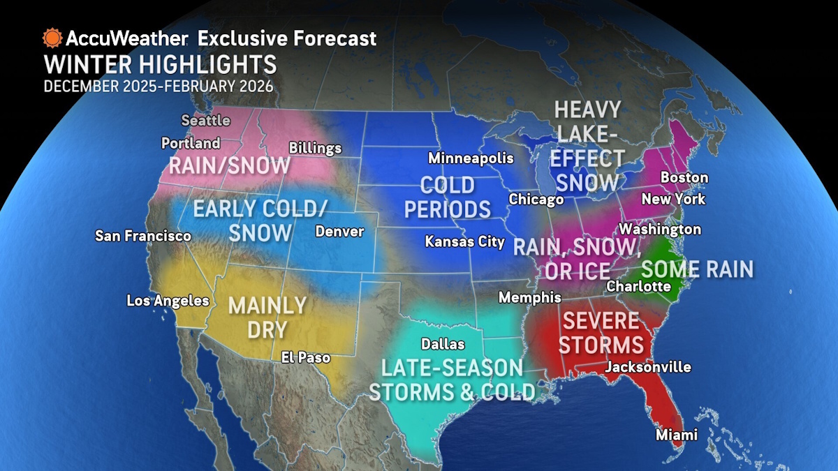
HIGHLIGHTS: From early snow to severe storms, the 2025-26 will be a diverse one. (Courtesy of AccuWeather)
“Some milder periods in between, but also some ice events. Impacts of La Niña conditions through January, stronger northern storm track,” Pastelok said. “Eastern Canada blocking forces storms in December south then northeast. More Pacific flow mid-winter, less arctic can lead to some ice events. Either a polar vortex or just a strong dip in the jet stream in late January or February can lead to cold surges.”
Old Farmer’s Almanac: Less intense cold and lower precipitation combine for a lighter-than-average snow season. Cold periods arrive in December and early January, with the snowiest conditions in mid-November, early and mid-December, and early February.
“Good news for those winter travelers, but gardeners may need to watch for an early thaw,” Perreault said.
Mid-Atlantic (MD, DE, VA, WV, NC)
AccuWeather: Near average temperatures overall, above average near the 95-corridor, eastern Virginia, and North Carolina. December’s temperatures are near average, January slightly above average temperatures, below average in February for the western parts of this region, and near to above far eastern. Precipitation will average above December-February western areas, near to slightly below eastern areas. Snowfall below average in most areas, with the exception of western Virginia, western North Carolina, and West Virginia, which can be near to above average.
Pastelok’s other factors — Cool fronts with possible Nor’easter development in December and February, followed by cold.
“Some milder periods in between, but also some ice events are possible in West Virginia, western Maryland, Virginia, and western North Carolina,” Pastelok said. “Impacts of La Niña conditions through January, stronger northern storm track. Eastern Canada is blocking cuts storms over the region. More Pacific flow mid-winter, less arctic can lead to more rain. Either a polar vortex or just a strong dip in the jet stream in late January or February can lead to cold surges.”

MOSTLY MILD: For much of the country, the Old Farmer’s Almanac is predicting a mild winter. (Courtesy of The Old Farmer’s Almanac)
Old Farmer’s Almanac: Milder and drier, with most snow falling around the holidays and late winter. Cold periods will be around mid- to late December and again in early and late January.
“Fewer snow days could ease commutes, but not as we get ready to usher in the new year,” Perreault said.
Southeast (SC, GA, AL, TN)
AccuWeather: Overall, near-average temperatures, above-average precipitation in northwest areas, near to slightly above average temperatures, near to slightly below average precipitation in southeast areas are expected. The coldest month could be February with a surge of cold and a lowering storm track. Ice is a concern in February in Alabama, Georgia, and southeast Carolina.
“Occasional chilly air masses may move south during December, especially early in the month, leading to an increase in heating demand,” Pastelok said. “A strong high in the southwest builds and creates a dip at times in the jet stream across the Southeast. Flow may flatten a bit in January, turning milder. Then, a couple of strong pushes of cold in February are possible.”

TEMPERATURE DEPARTURES: For the Midwest, forecasts are showing this winter is going to be a bit colder than average. (Courtesy of AccuWeather)
Old Farmer’s Almanac: A colder-than-normal winter with some snowy surprises in the east, especially around mid-December. In northern areas of the region, flakes fly in late January.
“Prepare for heating needs and occasional travel delays, especially before the holidays,” Perreault said.
Deep South (MS, LA, AR)
AccuWeather: Slower transition to winter across this area, as coldest air may slide to the north in early winter. Near-to-above-average temperatures and near-average precipitation are expected overall. December cold shots will have more influence across the northern nation. For this region, near-to-above-average temperatures are expected in December and January, occasional chilly shots, but not frequent. There is a bigger concern in late January and February for a higher frequency of cold shots. Snowfall will be near average (averages are low). Northern Arkansas will average closer to above for snow and ice, especially late winter.

PRECIPITATION: Much of the Southwest is forecasted to have less precipitation than average. (Courtesy of AccuWeather)
“Weak La Niña can lead to stronger push of cold across the northern part of the nation in December, but occasional chill can reach this region,” Pastelok said. “Probably more rain and ice, and cold in late December through mid-January, more Pacific air than polar air. Watch for the deep dive in the storm track late January or February for this area, possibly influenced by the polar vortex or just an amplified pattern caused by conditions in the northern Pacific.”
Old Farmer’s Almanac: Warmer-than-normal winter with some chilly snaps in mid-December, early and late January, and again in early February. Precipitation is forecast to be below normal, though northern areas of the region may see some snow as early as mid-November.
“Protect tender plants and outdoor plumbing before cold hits in January,” Perreault said.
Florida (FL)
AccuWeather: Above-average temperatures and below-average precipitation are predicted for the winter overall. November into December temperatures can be closer to average, but above in January and above for the peninsula in February. However, February can be near to below average on temperatures across the panhandle.
“Some power disruptions in November and early December can occur across the peninsula due to thunderstorms,” Pastelok said. “A charge or two of cold can reach the panhandle and northern peninsula, holding back temperature departures from being double positive to the current forecast.”

HEATING DEMAND:The South is looking like it will have below-average demand for heating. (Courtesy of AccuWeather)
Old Farmer’s Almanac: Winter will be cooler than usual, with a wetter-than-normal season. Expect the coldest temperatures in mid- to late December and a good portion of January.
“Snowbirds looking for winter relief should pack their sweatshirts, and natives need to be aware of gardens getting waterlogged,” Perreault said.
Great Lakes (MI, OH, IN, IL, WI) (Editor’s Note: Old Farmer’s Almanac moved WI to Upper Midwest)
AccuWeather: Overall, this region looks colder-than-average. December and February can be the coldest months compared to historical averages. Right now, we have near-average temperatures in January. This can go either way, above or below. We will come back to this month in December. The Great Lakes can produce higher-than-average snowfall. In addition, two storm tracks will fill in the gaps.
“La Niña-like conditions, fast-moving storms moving from west to east with some snow early in the season,” Pastelok said. “Wind and cold can follow each storm. A new storm track may start farther south and head northeast. More wind and cold can follow. A drop in the polar jet stream can occur later in the winter with some frigid temps. There could be a preview in December.”
Old Farmer’s Almanac: A warmer-than-normal winter with below-average precipitation and patchy snow. Coldest periods arrive in mid- to late December, early and late January, and yet again in early February. December will be the snowiest month, with more flakes flying in early and late January and early February.
“Be ready for lake-effect snow in December and March,” Perreault said.

SNOW DEPARTURE: Only a few pockets are expected to have more snow than average. (Courtesy of AccuWeather)
Upper Midwest (MN, IA, ND, SD) (Editor’s Note: Old Farmer’s Almanac included WI in this region)
AccuWeather: Overall, this region looks colder-than-average. December and February can be the coldest months compared to historical averages, with a few periods of frigid sub-zero air. Temperatures can average 2-4 degrees below average. Right now, we have near to above average temperatures in January. This can go either way, above or below. We will come back to this month in December. This could make a difference in which part of the range temperatures will be closer to the overall. Snow can average above across the eastern Dakotas and Minnesota.
“La Niña-like conditions, fast-moving storms moving from west to east with some snow early in the season. Wind and cold can follow each storm,” Pastelok said. “A new storm track may start farther south and head northeast. More wind and cold can follow. A drop in the polar jet stream can occur later in the winter with some frigid temps. There could be a preview in December.”
Old Farmer’s Almanac: Mild winter by local standards with some snowy bursts. Though temperatures will be above average, the area will still have cold spells on and off throughout December, again in early and late January, and once more in early February. The new year will hold the area’s best chances for snow — late in January and in early February.
“Shorter cold snaps may ease winterizing chores, but not enough to skip them altogether,” Perreault said.
Central Plains (MO, KS, NE, OK) (Editor’s Note: Old Farmer’s Almanac moved OK to Texas and Gulf Coast region)
AccuWeather: Overall, this region looks colder-than-average. December and February can be the coldest months compared to historical averages, with a few periods of frigid sub-zero air. Temperatures can average 1-3 degrees below average. Right now, we have near to above average temperatures in January. This can go either way, above or below. We will come back to this month in December. This could make a difference in which part of the range temperatures will be closer to the overall. Snow can average near to above, more likely above, in eastern Nebraska, eastern Kansas, and Missouri.
“La Niña-like conditions, fast-moving storms moving from west to east with some snow early in the season. Wind and cold can follow each storm. A new storm track may start farther south and head northeast. More wind and cold can follow,” Pastelok said. “A drop in the polar jet stream can occur later in the winter with some frigid temps. There could be a preview in December.”
Old Farmer’s Almanac: Winter will be warmer than normal with light snow and short cold spells, especially in mid-December and early and late January.
“Enjoy less snow removal overall, though late January and early February will be all shovel and snow play,” Perreault said.
Texas and Gulf Coast (TX, LA coastal areas) (Editor’s Note: Old Farmer’s Almanac included OK in this region)
AccuWeather: Temperatures December through February will wind up above average in west Texas and slide to near neutral east Texas and Louisiana due to late-season cold shots. December and January can be well above in west Texas, then turning colder late January and/or February. In far east Texas and Louisiana, temperatures can be near to slightly above in December and January, then below in February. Precipitation can be drier-than-average December through February for most of Texas, but near average eastern parts of this region. Near-average snowfall is expected, perhaps one or two snow and ice events in late winter.
“Drought and warm western Gulf will influence temperatures early on in the season,” Pastelok said. “With La Niña conditions early to mid-winter, precipitation will be hit and miss, more miss. A big charge can occur again this winter, especially around late January and February. This can lead to freezing temperatures for an extended period in Texas and parts of the Gulf Coast.”
Old Farmer’s Almanac: The region will experience a warmer-than-normal winter with occasional cold snaps, especially in mid-December, early and late January, and again in early February. Precipitation overall will be below normal for the season.
“Potential early northern snow in November could interrupt fall fests and football fun,” Perreault said.
High Plains and Rockies (MT, WY, CO, NM, eastern ID)
AccuWeather: New Mexico and Southwest Colorado will average above on temperatures in December through February. Elsewhere, temperatures will be near to slightly below. December and February, compared to the historical average, should be the warmest. January can be active with more frequent snow and rain, while February has some rain and snow, but less intense and frequent. Above-average precipitation and snowfall are expected in western Montana and northwest Wyoming. Near to below average precipitation and snowfall is likely elsewhere.
“This area will be on the fence between the cold east and warmth in the Southwest,” Pastelok said. “If a mean high-pressure area forms over the north-central Pacific, this area could be wetter and snowier. But if the high is more frequently east, then this area can be drier.”
Old Farmer’s Almanac: The region can expect a warmer-than-normal winter overall, though snow and cold will come in waves. Some of the coldest periods will arrive in mid-December, late January, and early February. The snowiest periods will occur in late February and then again in mid- and late March.
“Don’t put the shovel away too soon—late winter may bring surprises,” Perreault said.
Southwest (AZ, NV, UT, southern CA) (Editor’s Note: Old Farmer’s Almanac created a separate forecast for California)
AccuWeather: Warmer-than-average temperatures and below-average precipitation are expected for this region. January can be the wettest month, but still below average in many areas. Snowfall will be less than average. Still a chance for some cooling demand in November and early December.
“La Niña conditions through mid-winter keeps storm track north of this region most of the time,” Pastelok said. “But since the signal is weak, there can be some rain and snow across the central and northern parts of California. Southern California can get some rain in January, with a farther south storm track possible at times.”
Old Farmer’s Almanac: The region will experience a mild winter with mixed precipitation and fluctuating snow amounts. Late November, early December, and early February will offer some cool periods. Expect below-normal snow in the northern areas and above-normal snow in southern areas. Late January, early February, and late March will bring snow.
“Southern areas receive more snow than the north, but all should check forecasts before winter travel,” Perreault said.
California:
Old Farmer’s Almanac: California will have a warmer and drier winter with below-average mountain snowfall. Some cool periods arrive in late January and again in late February. Corresponding mountain snow is forecast to fall in mid-January and late February.
“The state can expect fewer storms, but should remain alert during late-season rain bursts in such dry conditions,” Perreault said.
Pacific Northwest (WA, OR, western ID, northern California)
AccuWeather: November, December, and in some areas, January will average above on precipitation, snowfall in the mountains. Above-average snowfall. February could end up less intense and drier, along with milder temperatures.
“Cooler water developing over the northeast Pacific, warmer water over the northcentral Pacific will set up a storm track heading into western Canada, the Northwest, and northern California,” Pastelok said. “A change later in the winter as La Niña fades and other drivers factor. The frequency can be less.”
Old Farmer’s Almanac: The region will experience a mild winter overall with some chilly spells and below-average precipitation. Though most of the season will have above normal temperatures, expect some chilly days in late November, early December, and early February. The greatest chance of snow will arrive in early February.
“Less snowpack could affect late-winter gardening and water reserves,” Perreault said.
Alaska (AK)
AccuWeather: Southern parts of Alaska can be drier-than-average and less cold. Central, northern, and eastern parts of the state can average near to slightly below on temperatures and near to above average on precipitation.
“Upper high pressure will poke north, possibly into the western parts of the state,” Pastelok said. “This can push the storm track farther north into central and northern Alaska. Cooler water temperatures in late October could work against this scenario and bring precipitation farther south along the southern coast.”
Old Farmer’s Almanac: Winter temperatures in Alaska will be above normal with reduced snowfall. The coldest periods are expected in early to mid-December and in mid-February. Though snowfall overall will be below normal, the area can expect flakes to fly in late November, mid-December, and again in early February.
“Winter travel may be easier, but there are still plenty of chances for snow,” Perreault said.
Hawaii (HI)
AccuWeather: Dry with above-average temperatures.
Old Farmer’s Almanac: Hawaii will have a warm winter overall with occasional stormy periods. Expect some cool temperatures in late November, late January into early February, and again in mid-March. Chances for storms will pop up in early and late November, early December, mid-February, and again in mid- to late March.
“Be on alert for heavy rain during November and December storms,” Perreault said.
Whether you require installation, repair, or maintenance, our technicians will assist you with top-quality service at any time of the day or night. Take comfort in knowing your indoor air quality is the best it can be with MOE heating & cooling services Ontario's solution for heating, air conditioning, and ventilation that’s cooler than the rest.
Contact us to schedule a visit. Our qualified team of technicians, are always ready to help you and guide you for heating and cooling issues. Weather you want to replace an old furnace or install a brand new air conditioner, we are here to help you. Our main office is at Kitchener but we can service most of Ontario's cities
Source link